Gata-Hurdes, Spain

Gata-Hurdes contains two adjacent mountainous counties: Sierra of Gata and Sierra of Hurdes. These two counties are located in the South-West of Spain, in the North of Cáceres, a province of Extremadura. The total surface of the territory is of 1757,31 km² (1257,94 km² Sierra de Gata and 499,37 km² Sierra de Hurdes).
Biophysical characteristics
The study area is characterized by Mediterranean weather of continental influence, with mild and rainy winters and warm and dry summers. The mountainous character of the study area generates a lot of heterogeneity in relation to temperature and precipitation. Precipitation ranges between 700 and 800 mm annually, being December the month with the largest amount of precipitation. Temperature averages 15°C degrees with large oscillations, with minimums of -4°C in winter and 43°C in summer.
Geomorphologicaly, the study area could be divided into Northern and Southern. The North is very mountainous, it occupies most of the surface and most of the urban settlements are located here. The highest point is the Pico Mingorro, 1627 m.a.s.l. (in Las Hurdes). The South is dominated by softer slopes and agricultural landscapes.
The orography is relatively sharp, with narrow valleys of strong slopes. Soils are rather poor and quite acid (Low in P and K, with a pH close to 5), despite their high organic matter content, not very nutritive and with relatively low agricultural potential, which determines the traditional silvopastoral use of the land.
The area is an example of typical Mediterranean vegetation, dominated by holm oak (Q. ilex) in the valleys and pyrenean oak (Q. pyrenaica) in higher altitudes. However, the natural vegetation is profoundly altered by pine plantations, that now cover a significant proportion of the forested landscapes. Recurrent wildfires resulted in a landscape dominated by pine forests, grasslands, heathlands and broom communities with small patches of natural Mediterranean forests.
Land use/land cover & landscape character
The most common land cover are scrublands, mainly composed by sclerophilic vegetation. It is mostly unmanaged, but there is some use of it for goat grazing. Another common land cover is pine forests, all of them planted during the second half of the 20th Century. Other relevant land uses are agroforestry (wood-pastures), grasslands, and olive tree plantations.
The landscape character of the study area is deeply influenced by the steep orography (which limited agricultural practices) and remoteness (far away from the main routes of commerce and transhumance).
This historical isolation has allowed the conservation of rich local, ecological knowledge and cultural heritage (characteristic local architecture; maintenance of the traditional orchards surrounding the urban areas; traditions, songs, and expressions related to the region; complex governance system to organize the use of resources such as water, etc.).
Agricultural land uses are goat grazing, fruit tree plantations, honey production and olives (these last one mostly in the lower parts of the study area). Perhaps the most characteristic impact of agriculture on the landscape are the terraced orchards that cover large proportions of the stepped slopes surrounding most of the towns and villages situated in the mountain valleys. These terraced orchards are traditionally used for growing different fruit tree species, as well as vegetable orchards. However, in the last decades, these terraced landscapes, as well as the traditional multifunctional landscapes around the towns have been progressively replaced by forests and dense vegetation that attract many tourists for their potential for recreation.
The study area has a large proportion of its surface protected under diverse schemes, especially Sierra de las Hurdes (i.e. natural reserves, natural monuments, areas of scientific interest, ecological corridors, areas of regional interest, etc.). Especially relevant is the Red Natura 2000, which protects under ZEPA and LIC approximately 64% of the surface in Las Hurdes, and 19% of the surface in Sierra de Gata.
Socio-demographic and economic characteristics
The study area shares some of the socio-demographic characteristics of remote rural Spanish regions. Rather low population density with a tendency to a reverse demographic pyramid. Socio-economic constraints and high unemployment favour a situation of high out-migration to bigger urban areas (Cáceres, Plasencia and Madrid).
Farming practices and contribution to the landscape character
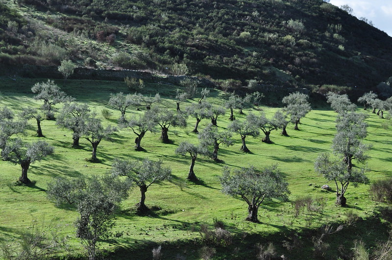
Olives are the major crop in almost every municipality in the study area. They occupy around 83% of the cultivated area and are especially abundant in the lowlands. They are generally cultivated without irrigation (although irrigation is gaining some importance in the last years) and producers are well organized in producers associations, which sell the olive oil at local, regional, and national levels.
Traditionally, olive tree cultivation was focused on the production of olives for consumption. However, in the last decades, the production has moved towards olive oil, which is geographically certificated under the label of Gata-Hurdes. There is also a growing interest in ecologic production, with some brands capitalizing on the positive roles of olive trees in the landscape (like wildfire prevention).
As for chestnuts, its surface of cultivation and landscape importance was bigger in the past as part of a mosaic of agro-silvopastoral land uses. Currently, as part of the MOSAICO project which is aiming to recover traditional landscapes to improve wildfire prevention, the cultivation of traditional tree crops is being stimulated (commonly smallholders with not many hectares of land). Within these initiatives, chestnut is playing a key role (especially due to its current market value, which makes of it a relatively profitable choice in comparison to other fruit trees) and several initiatives are associated with it.
Currently, unlike in other regions neighbouring Sierra de Gata and Hurdes, producers are not organized in any association, which hamper an improved commercialization of the chestnuts. Currently, chestnut are commercialized for its direct consumption (where goes the majority of the product), or for its industrial processing (for confectionery industry).
Socio-economic and cultural relevance in the landscape of production
Both landscape products, especially olive oil, are of great socio-economic relevance in the region. Almost 80% of the companies in the study area are related to the agricultural sector. Services with a focus in tourism are the main economic sector, but tourism relates to a great extent to agricultural landscapes and the social-ecological values associated with them.