Work packages
The nine WP, each characterised by tentatively defined milestones to which the partners from the five clusters contribute, are structured as follows.
Work packages
During the Watercope preparatory phase, first GIS -based maps of parts of the project region have already been established with the help of Corona and QuickBird satellite data and high resolution aerial images taken by a drone in 2008. Following the onset of Watercope in December 2011, metadata for the subsequent input of quantitative, spatially explicit results from stakeholder meetings & surveys; data on soil properties, land use, property rights, grazing orbits; as well as data on the profitability of existing and newly proposed production systems and household structure will be defined and procedures for data entry will be described. As a first step towards a comprehensive EIS the already existing literature repository about the project area will be converted into an internal database (web-portal). For the duration of the first three year project phase this database will be for internal exchange and monitoring of project progress only and therefore password protected. As soon as maps, progress reports and handbooks are available, these will be entered and a tri-lingual web-based EIS ‘TransborderResources’ will be made available to the public allowing stakeholders and policy makers in the project area and neighbouring countries to use the information compiled.
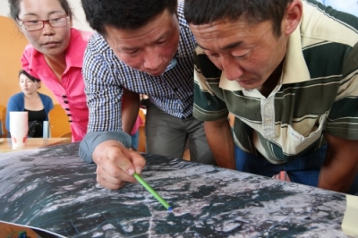
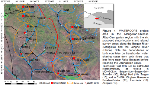
Starting in April 2012, a 6-months PRA will be conducted by the Mongolian and Chinese PhD students and supervisor representatives of all clusters to analyze the pastoral and agricultural land use systems along the watersheds / altitude gradients in both countries. In each of the six villages (see project area) village meetings will be held followed by stakeholder meetings in Bulgan and Qinghe. Qualitative and quantitative information obtained will be processed and uploaded into the internal web-portal. The Baseline Survey will allow to
(i) identify the main environmental, socio-cultural and economic characteristics of the study area,
(ii) choose households for in-depth investigations and
(iii) permit selection of representative sites within different land use units (greenhouses, private fields, open rangelands)
at each location for subsequent participatory on-farm experiments and final test-implementation of ‘Best-fit Coping Strategies’.
Between cluster cooperation will be essential to define and supervise the PhD theses of 8+8 PhD candidates / post-doctoral scientists from Mongolia and China plus 2+2 MSc students working in the five clusters. All of these junior researchers will be tandem-supervised by teaching institutions from Mongolia, China and Germany. Once the web-portal has been developed into an EIS, the PhD candidates will participate in workshops for innovation-based scenario testing with local planners in Bulgan (Mongolia) and Qinghe (China).
The interdisciplinary PRA, informal surveys and formal questionnaires will be used to analyze - at each of the six locations (see Project Area) - how current livelihood strategies work, how they determine household income and risks with respect to market prices, declining pasture availability and climate change-induced availability of water. The surveys will also tackle decision making processes of herders and farmers for their land use choices, thereby taking into account local / traditional knowledge.
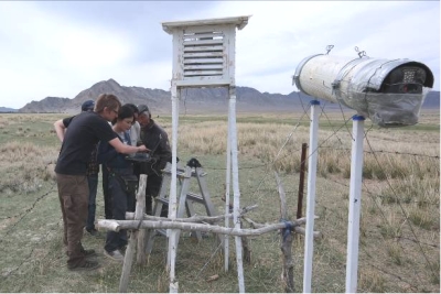
During the first two years we will examine key factors that determine ecological and socio-economic resilience, and essential ESS&F in the project region. Among other approaches, bi-annual meetings and consultations will be held with farmers/herders and other local stakeholders to jointly evaluate the relevance of these factors through discussions, quantitative field monitoring and experiments at the six study locations. After the project’s second year, we will jointly identify a set of easy to use bio-physical and chemical indicators that reflect the capacity of the system to provide essential ESS&F. Likewise, indicators describing socio-economic resilience, such as household income, competitiveness of agricultural production, and livelihood-specific availability of critical natural capital, will be established.
For more information, check first results shown for the clusters.
PRA-collected herder and farmer knowledge, local and regional decisions makers’ priorities, experimental evidence about the effectiveness of resource efficient land use strategies and sustainability indicators will be used to identify ‘Best-Fit Coping Strategies’ with the explicit aim to increase household income especially for poor local ethnic minorities. Given increasing per capita water scarcity, a particular focus of Watercope will be on enhancement of household income per unit of water employed, allowing local people to pay for increasing amounts of imported food while maintaining ESS&F. Among such ‘high revenue per unit water strategies’ (value chain approaches) could be high quality cashmere and camel hair production-processing-marketing, intensive vegetable production for local and regional markets (peas, beans, tomatoes and mushrooms in greenhouses), and cultivation of salt and drought tolerant organic buckthorn for the production of juice and jelly. Further promising alternatives will be discussed with stakeholders to develop other high value commodity chains. For the identified alternatives, improved management techniques such as strategic herding schemes adapted to different rainfall scenarios, specific fertilization and irrigation schemes or pruning regimes will be test-implemented jointly by scientists, farmers/herders and other stakeholders in pilot projects.
GIS -based scenario analyses based on a socio-ecological understanding of herders’ / farmers’ decision making in the wake of resource conflicts & climate change effects (including PRA results), multi agent models and adapted SIAT will be developed and used for the assessment and spatial upscaling of the user-tested ‘Best-fit Coping Strategies’. All generated data will be fed into the EIS and used to derive the respective ESS&F demands under the previously described scenarios of socio-economic development and climate change.
Training of planners and policy makers in WP3 will be intensified during the last year of the project. A PAM study on the private and social competitiveness of key agricultural production activities will be conducted, and their dependence on regional and national policies established. This will contribute to predictions of how alternative livelihood strategies and supporting policies enable stakeholders to cope with anticipated climate and socio-economic changes and how those improved coping strategies affect household income and risk.
For first results of the PAM check Cluster 5 (Socio-economy).
Based on the results of the PRA in April 2012, the 2 years survey and analysis of pastoral and agricultural communities’ priority settings and value systems the effects of jointly developed ‘Best-Fit Coping Strategies’ on markets demands, household income, resource competition, system resilience and ESS&F provision will be analysed using the developed indicators. Enabling institutional arrangements and constraints will be identified, and the effects of these arrangements as well as of national policies, and global trade liberalisation on the livelihood strategies will be investigated considering system resilience and scenario development. Through village meetings and involvement of traditional village chief structures into participatory evaluation tasks and scenario analyses we will make sure that the needs of ethnic minorities in the project area (i.e. Kazakhs) are included.