High Atlas, Morocco
The study site is located within the administrative borders of the rural commune of Imegdal, situated in the High Atlas Mountains in Morocco. Imegdal is located on the edge of the Toubkal National Park (est. 1942), which includes the tallest peak in Morocco, Mount Toubkal (4167 m.a.s.l.).
Located around 70 km away from Marrakesh (the 4th largest urban centre with internationally connecting flights), Imegdal is on the tangent of tourist attractions in the High Atlas Mountains. The village Imlil (approx. 15 km from the circle capital Asni) houses various hospitality services and tourist offices focused on High Atlas trekking.
Another sight in this place is the Kashbar du Toubkal which in 1997 served as the location for the filming of Martin Scorsese’s Kundun and now is a luxury hotel. Besides the scenery, the road passing through Imegdal is one of the two directly connecting routes from Marrakesh to Agadir (R203 approx. 300 km or 7 hours driving according to Google Maps). The rural commune is the smallest administrative unit in Morocco. Imegdal is located in the Ouirgane district within the circle of Asni in the province of Al Haouz, with its capital Tahannaout. Al Haouz is part of the economic region of Marrakesh-Safi. Imegdal covers an area of 278 km² with 30 villages. The nearest towns are Ouirgane, Amizmiz, and Asni; which are some of the largest towns in the province of Al Haouz.
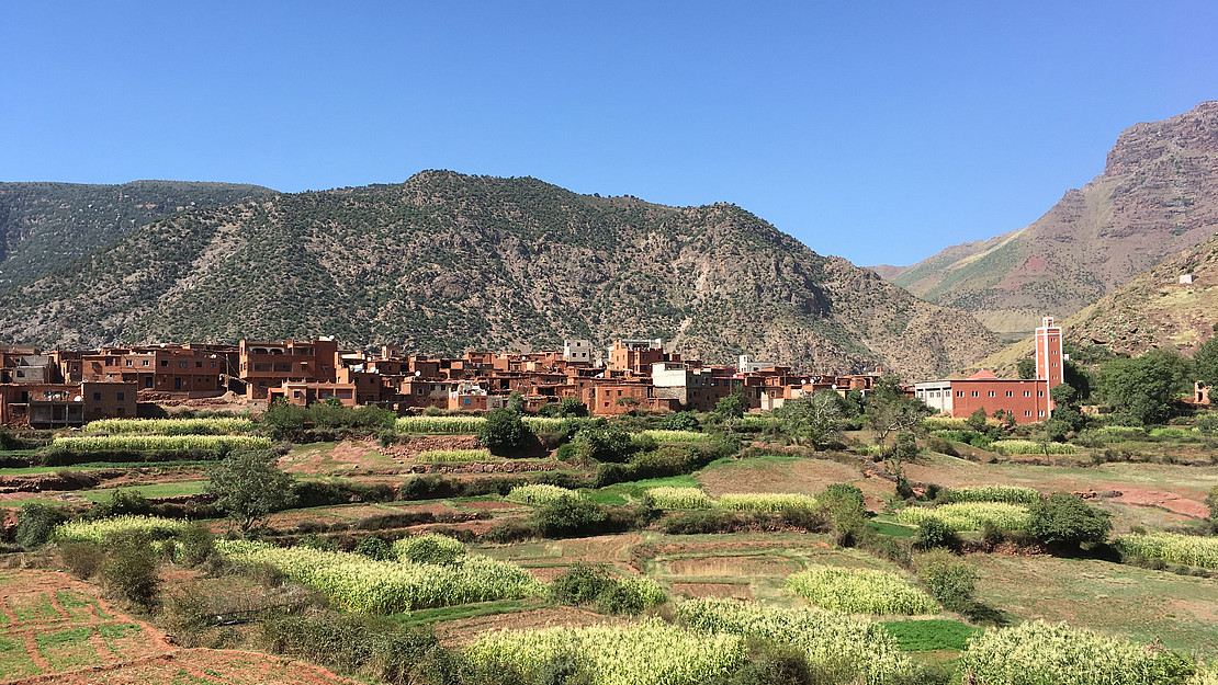
The area we are concerned with is the Znaga Valley, which covers an area of 6-7 km2. There are 9 douars or villages in question, namely Warti, Annamer-Taourirt, Wasentout (or Wakhefamne), Tizi M’lil, Makhfane-Ourigh, Ighrem-Tiniskt. Makhfane-Ourigh and Ighrem-Tiniskt are in the low valley, the others are considered high-valley. The villages in the low valley have a higher number of inhabitants than those in the high valley.
Biophysical characteristics
The commune of Imegdal is located in the High Atlas Mountains near Toubkal, which is the highest peak (4167 m.a.s.l.) in Morocco. It is located in the mid- and high valleys area, with altitudes that range from 1000 m.a.s.l. to 2500 m.a.s.l. The mid-valley zone is characterised by altitudes ranging from 1000-1200 m.a.s.l. formed of ridges and hills of low altitude. The high valleys, above 1200 m.a.s.l., are characterised by Permo-Triassic plateaus.
Imegdal is characterised by a semi-arid Mediterranean climate with hot-dry summers (max temperature is 42°C) and cold-wet winters (max -2°C) and an average temperature of 28°C. The annual precipitation is about 300 mm. The main watercourse is the river Oued n’Fiss. Water resources in the area are scarce due in part to the intense local water use. Geologically, the area is formed by ancient earth formations (Cambrian) and consists mainly of shale and limestone.
Morocco is known for a high number of endemic plant species (22% of known species) where 49.1% are found in the High Atlas (Rankou et al., 2013). The main ecoregion in the commune of Imegdale is covered by sclerophilic forest which is characterised by meadows, open grasslands, and woodland (especially with tree species Quercus sp., Tetraclinis sp., Juniperus sp., and Pinus sp.).
Land use/land cover & landscape character
We find differences in the mid- and high valley zones based on the climatic conditions and the associated crop and tree species as well as the intensity of livestock production. In the mid-valley zone, bowls of humidity make it possible to cultivate annual and perennial (tree) crops in terraces, especially apples, almonds and olives. The lifestyle is dominated by pastoralism with goats and sheep. In the high-valley zone, the main livelihood system is silvo-agro-pastoral with a main cultivation of walnuts and cherries, and sheep as the main group of livestock. The areas of cultivation are restricted to the narrow valleys which create microclimates making cultivation possible. Approximately 80% of the mountainous surface is covered by degraded forest and woodland.
The overall character of the cultural landscape results from the combination of the extreme topography, the silvo-agro-pastoralist livelihood system and the sparse natural vegetation.
The High Atlas Mountains are characterised by two complementary and integrated land uses:
- the intensive manual labour cultivation of privately owned, irrigated terraces, and
- herding of goats and sheep to the high altitude pastures, regulated as a common resource known as agdal.
These two systems used to be in balance: in summer animals would exploit land areas with little possibility for cultivation and the manure from the winter period that was accumulated in the stables would be used as fertilizer in the terraces in spring. This sustainable system of the agdals is suffering under climatic and societal dynamics and is widely researched.
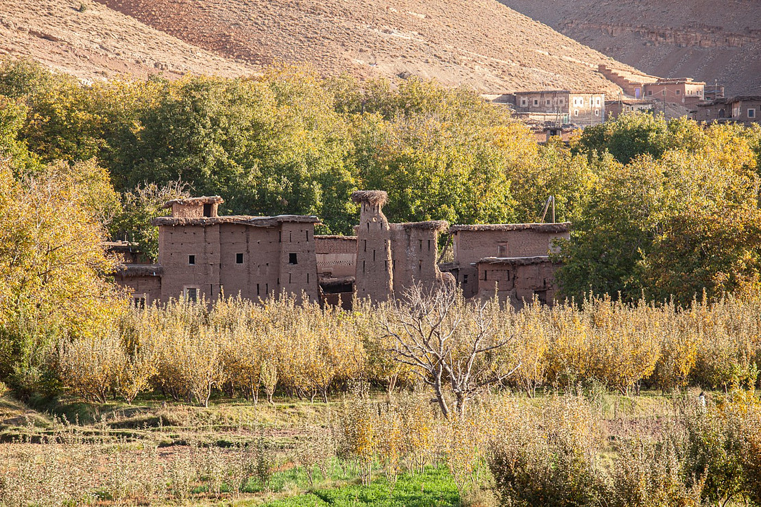
A feature characterising the agricultural landscape is the irrigation channels, seguia or targa, which are overground channels which carry water from the high mountains and distribute it along the terraces. The sequias are linked to large rainwater storages, khettara, which have been dated back to the end of the 12th century. Today, the original sequias constructed in clay and soil, are still in use but the traditional materials have been replaced by concrete in order to ensure a more efficient flow with reduced spilling. The houses in the villages are also constructed using local materials such as stones and clay. This also gives the landscape a unique character in the way that the village almost blends into the mountainside.
Morocco has a high number of endemic species and 49,1% of the known species are found in the High Atlas Mountains. The endemic species in Morocco belong to 55 families and 287 genera; the five most common families are Asteraceae (counting 166 different taxa), Fabaceae (108), Lamiaceae (99), Brassicaceae (61), and Caryophyllaceae (59).
As several species are being collected in the wild and used locally or being sold at the market as medicinal plants, there have been initiatives to secure ex-situ conservation in order to later reintroduce them into the wild.
Socio-demographic and economic characteristics
The commune of Imegdal is dominated by the ethnic group Amazigh, who are indigenous to the Atlas Mountains as well as other large parts of the Maghreb. Amazigh people are divided into tribes according to their distributing throughout the mountain range and different languages are spoken between the tribes. In Imegdal, people speak mainly Tamazigh or Tachelhit, and only a small part of the population speaks dialectical Arabic, darija (Montanari, 2013).
The social system is strictly gendered with certain roles ascribed to men, women, and children. Generally, men are favoured in terms of basic education as women or girls are regarded as valuable for housekeeping, taking care of younger and older family members, as well as working in agriculture, especially gathering fodder.
In 2004, the commune had 5537 inhabitants and 1044 households.
Socioeconomic conditions in the province are challenging. From making an income exclusively from agriculture in the past, today most families find themselves forced to seek additional income in and out of the region.
This implies that on average, one man per family is absent for part of the year, thus women undertake a large part of the agricultural work. The population has decreased -0.02% every decade over the past 20 years because of the aforementioned reasons.
According to the census, Al Haouz province has a high proportion of youth (<15 years) which equals 41,4% of the population. In comparison, the working-age (15-59 years) equals 50,8%. The circle of Asni has a high representation (38,7%) of young people (<15 years). The proportions between high levels of youth can partly be explained by the high levels of immigration of the working-age population.
Generally, men are more active in the labour market (50,63%) as compared to women (14,19%). This is steadily being changed by establishing cooperation groups to empower women across generations, which is regarded as important for rural development .