Maâmora Forest, Morocco
The Maâmora forest is located in the north-eastern part of Morocco. With a current total area of about 1.330 km² (including enclaves), Maâmora forest used to be considered as the world’s largest oak forest.
Indeed, the potential area of cork oak in the Maâmora plain is considered around 3.000 km². However, the actual cover is considered effectively around 500 km², with a highly degraded, almost absent climax. In fact, cork oak currently occupies mostly the western section of the forest where the ecosystem is more resilient due to influence from the Atlantic Ocean and the sandy nature of the soil. The eastern section experiences a drier climate and is characterised by harder substrates, where cork oak has almost completely disappeared.
With the products and services that it provides, Maâmora forest is one of the most important forests in Morocco. It significantly accounts for the needs in fuelwood, grazing for livestock, recreation, etc. for more than ten communes.
Maâmora straddles two economic regions:
- the Gharb-Chrarda-Béni Hsen region, which includes the provinces of Kenitra and Sidi Kacem, and
- the Rabat-Salé Zemmour-Zaër region, which is part of the Salé prefecture and the Khémisset province.
The Maâmora forest is part of the state-managed forest domain. It is managed by the directorate of the North-West, the directorate of Kenitra (for its northern half), the directorate of Rabat-Salé-Zemmour-Zair and the directorate of Khemisset and Rabat (for its southern half). This forest massif is divided into five distinct parts, separated from each other by rivers.
Biophysical characteristics
Bioclimatic conditions range from sub-humid with warm winters in the western part, to semi-arid with temperate winters in the central and eastern part. The continentality is manifested by the gradual decrease in rainfall from west to east. Precipitations range from 400 mm in the East to 600 mm in the West (50 km far from the East). Conversely, there is an increase in the average temperature from west to east.
Maâmora is characterized by a generally flat or slightly undulating topography, sloping towards the NNW with a slope of about 6% to 8%. The highest point (300 m.a.s.l.) is located southeast and the lowest in the northwest (7 m.a.s.l.). The landforms are determined by the recent dune system, tectonics, and the importance of the sandy cover.
Thus, we can distinguish three types of reliefs:
- Western Maâmora (cantons A and B), not very influenced by tectonics with a sandy cover often very large and with medium slopes;
- Central Maâmora (canton C) having undergone the strongest tectonics, with a steep slope and where erosion is more pronounced and
- North-eastern Maâmora (cantons D and E), which is the lowest part of the gently sloping and eroding Maâmora.
Five wide-valley wadis separating the five forest cantons drain surface water to the Gharb plain, namely Oued Fouarat, Oued Foui, Oued Smento, Oued Tiflet, and Oued Touirza. Only 15% of precipitation benefits the groundwater table.
The substratum of the area is based on marl formations that constitute the water table level or on Pliocene sands and sandstones. Above these layers, a continental deposit of variable thickness has been deposited, which can reach a thickness of about twenty metres in places, known as the red clay of the Maâmora of the “Upper Villafranchian”. Following these deposits are sandy formations with a thickness of 1 to more than 6 m, which are of two types: a) siliceous red sands rich in iron oxides and possibly containing a little clay; and b) pink to siliceous beige sands, more recent and devoid of clays. The origin of these sands comes mainly from the oblique leaching of the red formations of the Maâmora.
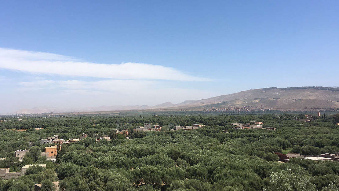
The vegetation of Maâmora is mainly comprised of cork oak (Quercus suber), even though it has decreased in area lately, giving space for eucalyptus (Eucalyptus sp), pine (Pinus sp), and acacia plantations (Acacia sp). The Maâmora counts with many vascular species; more than half are therophytes. There are 408 specific and infraspecific taxa, belonging to 261 genera and 62 families and one can still find 30 national endemic species.
Land use/land cover
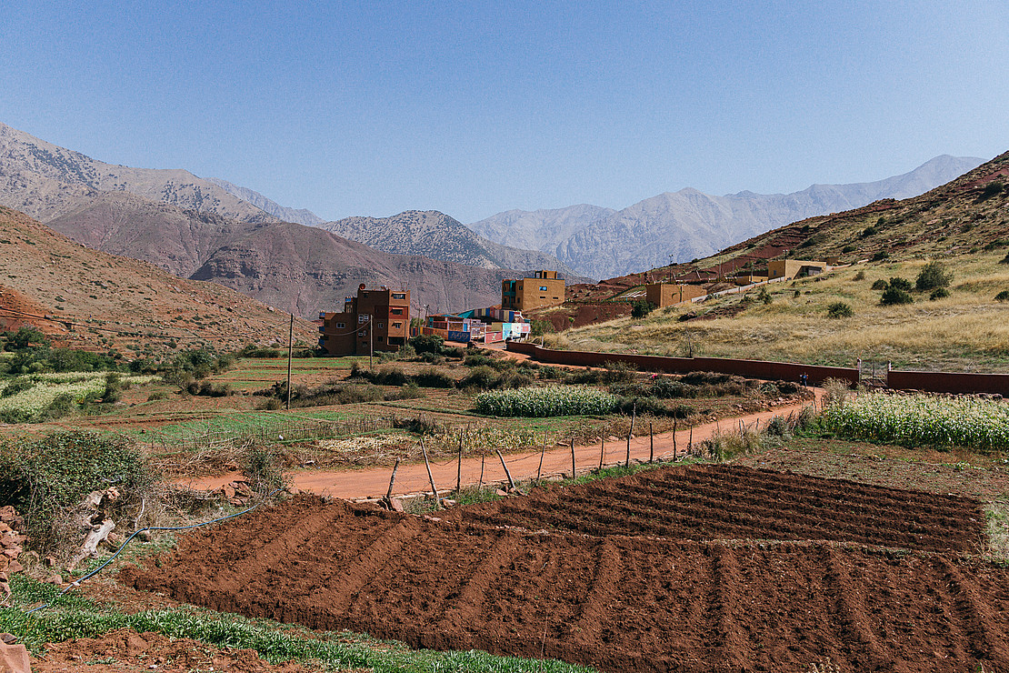
The study area is mainly covered by forest, partly extensive open stands and partly plantations, which are used mainly for cork production. Eucalyptuses also covers an important area of the forest, followed by pines and acacias. People live, grow crops, and perform herding/grazing activities in the areas in between the forests. Therefore, other agricultural uses and grazing are dominant land covers too; rural settlements cover little surface and the few small cities even less.
The result is a multifunctional landscape of cork oak and eucalyptus plantations over large intensively managed areas; settlements along the roads; and farming/herding/grazing lands around the settlements.
Landscape character
The Maâmora forest is characterized by softly rolling hills that form a plateau at a relatively low altitude (average 300 m.a.s.l.). Natural valley structures developed to be the infrastructural pathways, which lead through the forest.
Different types of cork oak forests can be identified based on their density: The dense cork oak forest (more than 200 trees/ha) covers only 4.110 ha against 16.665 ha for the medium-density (100-200 trees/ha), and 37.621 ha for open forest (less than 100 trees/ha). Especially the less dense cork oak landscapes can be like a savannah. The plantations of eucalyptus result in denser forests and at the same time are more intensively managed.
The agricultural areas are partly open areas with very scarce vegetation and a considerate share of bare soil areas (especially in autumn), where erosions gullies can be found frequently. The cultural aspects of the landscape are made up of large cork storages, small to medium rural villages with nearby fruit and vegetable plantations, grazing activities, charcoal production sites, and plant nurseries. Further, the landscape is influenced by the steadily growing infrastructure network of asphalted roads.
Socio-demographic and economic characteristics & Landscape dynamics
In 2019 the region had 4.818.923 inhabitants with a population density of 272,4 inhabitants per km². 30 per cent of the population is considered rural. The main economic sector in terms of GDP is services and employs 40% of the population. Agriculture employs 39% but only contributes to 14% of the GDP.
The social-ecological changes that have happened in the study site are associated to changes in the management plans and becoming part of the EU-market, the construction of transport infrastructures connecting the areas with urban centres, socio-economic changes, and market-economy transition. Furthermore, upcoming urbanization near and within the forest puts economic and thus ecologic pressure onto the ecosystem.
Farming practices and contribution to the landscape character
Cork is “farmed” large-scale industrial. There are two types of cork oak landscapes in the study site:
- those with relatively old stands, and
- those with quite new plantations.
The lower-quality “virgin” cork is harvested during the first extraction after approximately 25 years. Then, every 9-12 years “mature” cork of better quality can be harvested. The harvesting of cork requires skilled workers to avoid lethal damages to the trees.
Compared to most cork oak sites in Spain or Portugal the Maâmora forest is under huge anthropogenic pressure from different forms of usage which decreased natural cork regeneration to almost zero.
The regeneration efforts through seedlings lead to artificially looking cork oak plantations (almost without shrubby vegetation) in contrast to the more open, spacious stands of old cork oak trees. If the older stands are managed in sustainable ways they form typical areas which look like savannahs that seem natural but are highly cultural landscapes.
However, the single most defining “practice” for this specific cork oak landscape is the high pressure from different uses, which creates smaller patches and more mosaic or linear structures.
Socio-economic and cultural relevance in the landscape of production
One of the values of the Maâmora forest lies in its significant and decisive role in economic and social activity at the local, regional, and even national levels. It offers significant and diverse resources.
On the one hand, it constitutes an important reserve of cork (47% of national production), industrial wood (85% of national production), and offers secondary products such as acorns (600 kg/ha/year), mushrooms, and truffles (30 t/year). On the other hand, it allows users to collect dead lying wood (87% of the area's needs) and to graze on land that has not been cleared. In addition, it also plays an important role in job creation (300.000 working days per year), beekeeping (1000 t/year of honey), and hunting.